This is the second part of our Inca Trail hike, if you haven’t read the first part you can read it here.
Day 3
Our guides told us that now that we had finished the hardest part of the hike we had the best day in front of us. Beautiful views and lots of ruins. And they didn’t disappoint. First up we had to hike to another mountain pass, but it was “only” 500m up instead of 1200m the day before.
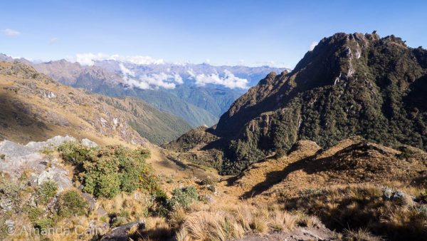
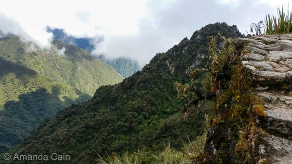
The Cloud Forest
From the pass we could see that the landscape changed. The day before was dry and rocky, but ahead of us was the cloud forest. This is an area with clouds floating along the mountainsides, keeping the air nice and humid. So everything is very green, and there are all sorts of colourful orchids, mosses and lichens covering everything. As well as hummingbirds zooming around between the flowers.
The Day of Inca Ruins
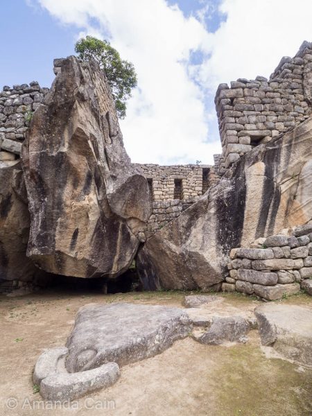
Archaeologists believe that the Inca Trail was built as a religious pilgrimage to the sacred city of Machu Picchu. With stops along the way for pilgrims at temples and shrines to make sacrifices and purify themselves. We saw a few ruins on the first two days, but Day 3 was when we kept stopping regularly to explore large and beautiful ruins.
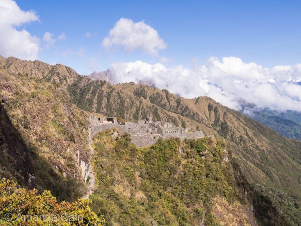
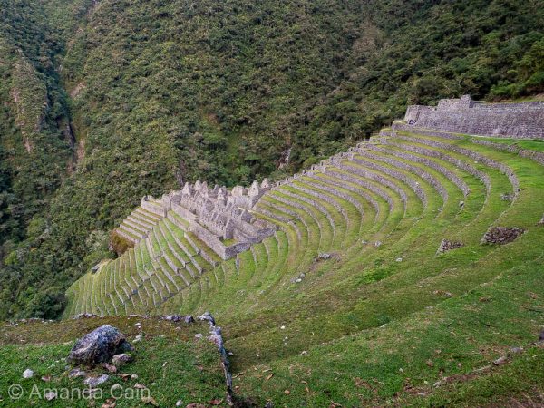
The first one was Sayaqmarka looking out over the valley of the cloud forest. The Incas really knew the best spots to build their cities. Although I did spend a lot of time cursing them under my breath the day before for building them so high up the sides of steep mountains. And for putting in stairs instead of nice gently sloping ramps. But this day the altitude was lower, the plants were lush and green and the views were spectacular, so I was ready to forgive them.
Safety: Optional
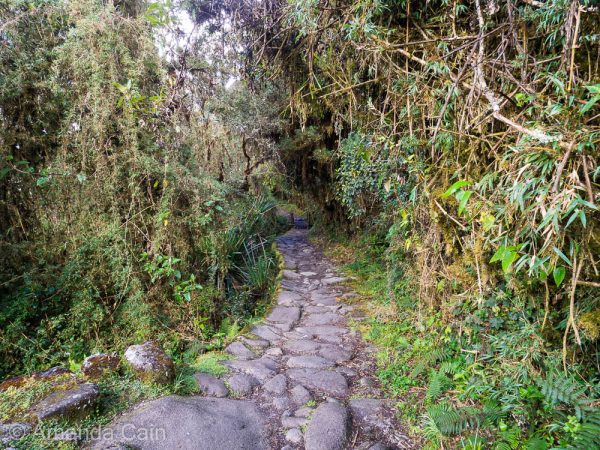
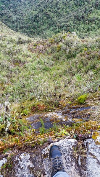
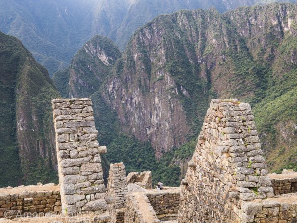
With the spectacular views over the steep sided valleys, you also get steep drop offs along the trail. And no safety rails or anything. As well as plenty of VERY steep stairs ending at a cliff with no wall or anything to hold you back in case you stumbled. The Incas weren’t big fans of self-preservation. Natural selection took care of the clumsy ones. Most of the Inca Trail is on the original road built in Inca times so this is what the pilgrims walked along as they made their way to Machu Picchu.
The Gringo Killer
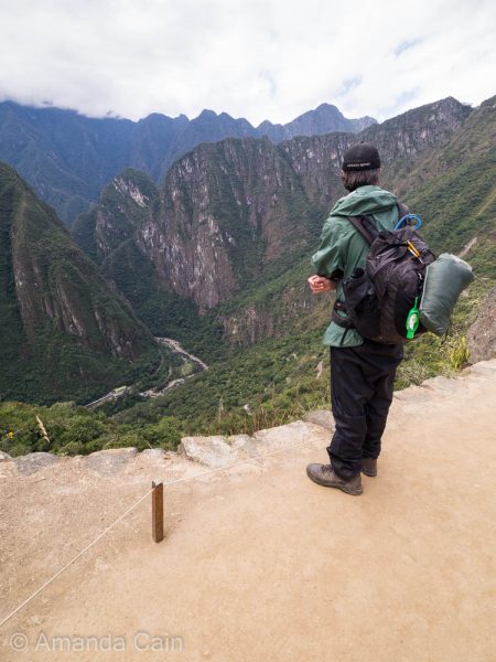
We stopped for lunch at the third and final mountain pass. From here you can see Machu Picchu Mountain, with the city on the far side of the mountain. Our goal was finally in sight! After lunch was the notorious Gringo Killer. A long, steep staircase that drops 800m. It absolutely destroys your knees. I was limping around for a week and had pain in my knees for a whole month afterwards. This is the section where you most appreciate having the trekking poles. After a bit of experimenting we worked out that it was easier on your knees if you ran down the stairs rather than slowly stepping down.
Saving the Best Till Last
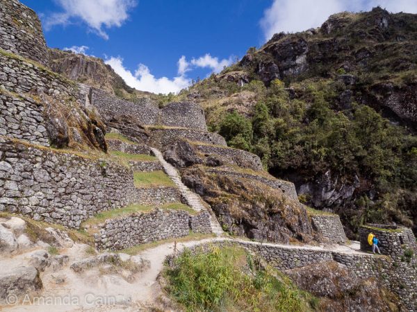
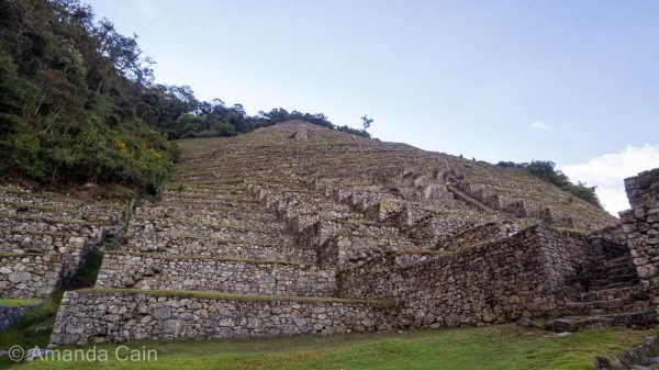
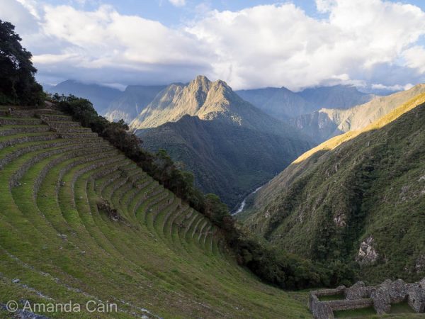
Once we made it to the bottom of the Gringo Killer we arrived at one of two very impressive ruins near our campsite. The first was Intipata, a series of endless terraces built into the side of the steep mountain. There’s a big section of it that has been restored, but along the trail we could see remnants of other terraces so it looks like the whole mountainside must have been terraces in Inca times.
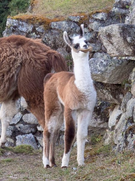
There were also a group of semi-wild llamas wandering around the ruins here. And a very adorable baby llama that we spent way too much time watching.

For both of us, our favourite ruin was Wiñay Wayna. It was actually our favourite in the whole Inca Trail, even beating Machu Picchu. It was the largest site after Machu Picchu, but the best bit about it was that it was so beautiful and peaceful. There were only two other groups exploring the ruins so it really felt like you had the place to yourself (Machu Picchu is actually super crowded). And with the spectacular views over the valley this made it an incredible place.
Day 4
Whose Stupid Idea Was it to Get Up this Early?
The early start on Day 4 is stupid. This isn’t me complaining about not getting enough sleep. If it’s necessary I’ll do it without complaining. But there is no point to getting up at 3:30am on this last day because no one allowed to hike until 5:30 anyway. So what do you do in this time? You sit outside the ranger station in the dark and cold for two hours and freeze. The only purpose to this is to line up in starting order for the hike. Unfortunately there are some super competitive people that feel like being first to Machu Picchu is the whole purpose of the Inca Trail. So because of this, groups get up earlier and earlier to try and be the first group through the checkpoint.
The Final Hike to Machu Picchu
This final section of the Inca Trail is quite narrow with more steep drop offs, and you hike in the dark because the goal is to get to the Sun Gate for sunrise. So it’s a bit dangerous. What makes it worse are the super competitive people who try to overtake along the narrow, crowded path. Our guide told us that the year before, 3 people had died from falling off this section because they were trying to run ahead. And he’s seen plenty of fights break out between hikers because people are pushing in to get in front.
This was actually my least favourite part of the Inca Trail. Instead of getting excited about getting to the Sun Gate and finally seeing Machu Picchu, I was getting frustrated fending off people trying to overtake. It was like driving around in peak hour traffic. If you left even the tiniest gap between you and the person in front then someone would dart in front of you. And they would then complain loudly if they couldn’t get past or if the pace slowed the tiniest bit. It’s not like we were going slow either. It was a continuous line of hikers the whole way to the front so we were going as fast as the conditions allowed. Our guide had to keep telling them off and telling them that there was plenty of time for everyone to make it to the Sun Gate before sunrise.
Sunrise Over Machu Picchu
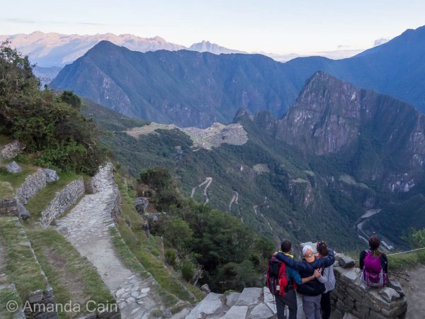
After nearly an hour and a half we had one last climb up a near-vertical set of stairs before suddenly a stone gateway appeared in front of us. And beyond that the sacred city of Machu Picchu perched on a mountain above the valley. We made it!
The location of the Sun Gate is no coincidence. On the winter solstice, the rising sun shines through the gate and through a specially placed window into the Sun Temple (in Machu Picchu). There’s actually another window that lines up with the summer solstice and they’ve found the remains of an old trail leading up to another mountain pass where they think they might find another sun gate. They’re still excavating it, so maybe in a few years we’ll see!
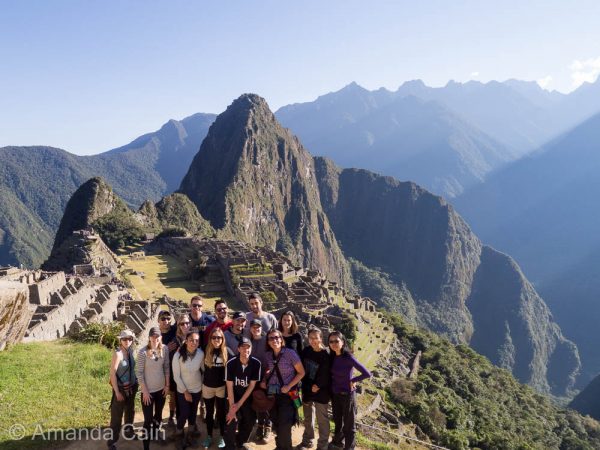
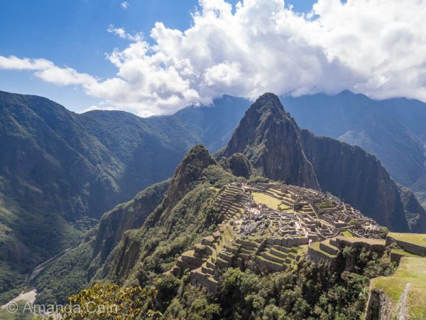
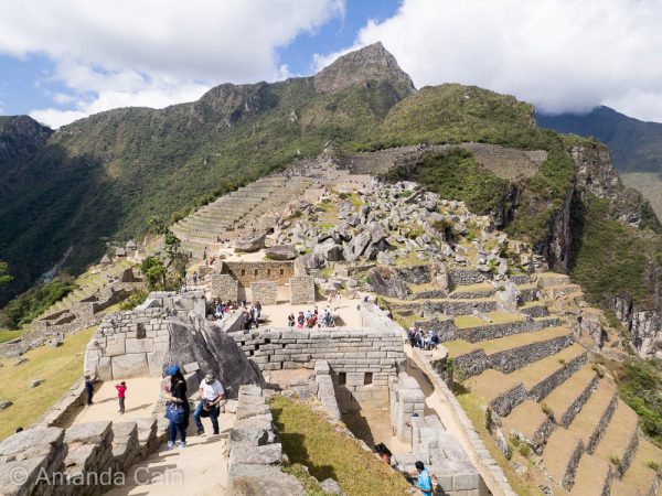
The Grand Finale: Machu Picchu
On our way down into the city the sun came up and we watched the shadows creep to the bottom of the valley, pushed back by the beautiful golden sunlight. There was a nice gently sloping path leading down the city (finally a ramp!) which felt like a victory road. And at the end, that picture perfect view of Machu Picchu that’s in everyone photo albums.
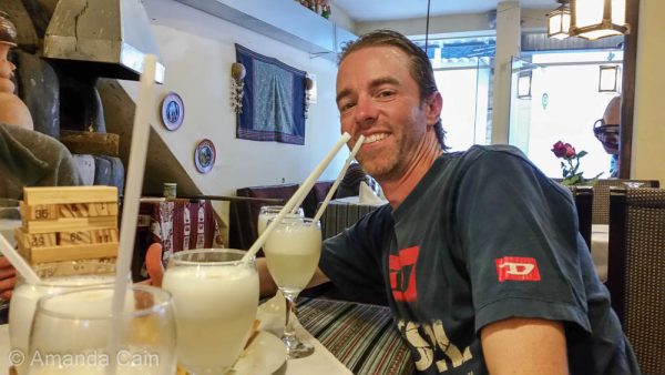
Eventually, after several hours exploring it was time to head down the mountain to the town of Aguas Calientes where we celebrated finishing the Inca Trail with the national drink: Pisco Sours.
Day 5
You didn’t think it was over yet did you?
One Final Hike
We booked an extra day in Machu Picchu to explore it further, and to hike up to the top of Machu Picchu Mountain. It seemed like a good idea at the time. But now after 4 days of hiking, and me battling a chest infection, we were having second thoughts. Especially when we saw this the day before.
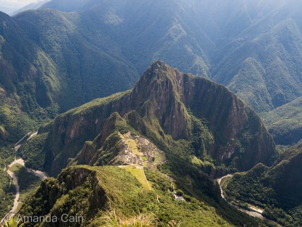
Wayna Picchu is the mountain that’s in the background of all the photos of Machu Picchu. It looks big and impressive. It’s actually only half the climb of Machu Picchu Mountain. We weren’t sure if we were going to make it. Especially not after standing in line for the bus to Machu Picchu for nearly 2 hours. Our feet were already tired, they didn’t need more punishment.
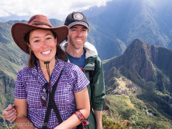
But stubbornness won and we decided to go for it. It took the better part of 2 hours, and like hiking up to Dead Woman’s Pass the top didn’t seem to get any closer. But every time we stopped at a lookout, Machu Picchu got smaller and smaller. So it did feel like we were making some progress. Eventually we got to the top and were rewarded with spectacular views of all the mountains around.
The Verdict
So there you have it, our Inca Trail journey over five days. We hiked 43km in 4 days. Compared to the W Trek in Torres del Paine, we reckon the Inca Trail is actually easier. Even with the altitude. There’s half the distance to cover, and the terrain is a well-maintained Inca road rather than the rough trail over loose rocks in Torres del Paine. We’re very happy to have completed two of the great treks of the world. We hope there will be more to come in the future.
Fun fact
The record holder for completing the Inca Trail is a porter who managed to do it in under 4 hours. The Gringo record holder (professional marathon runner) did it in just under 6 hours. The porters really are superhuman.
I can just imagine the extra energy and effort required to reach all those higher mountains.
Fantastic super trip, that is something impossible for me to achieve now, so just happy to see you both accomplishing your well deserved achievement, needing lots of physical stamina and determination, perseverance.